Plan Framework
Mobility
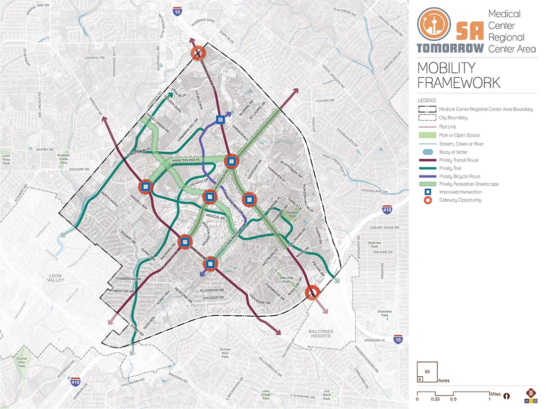
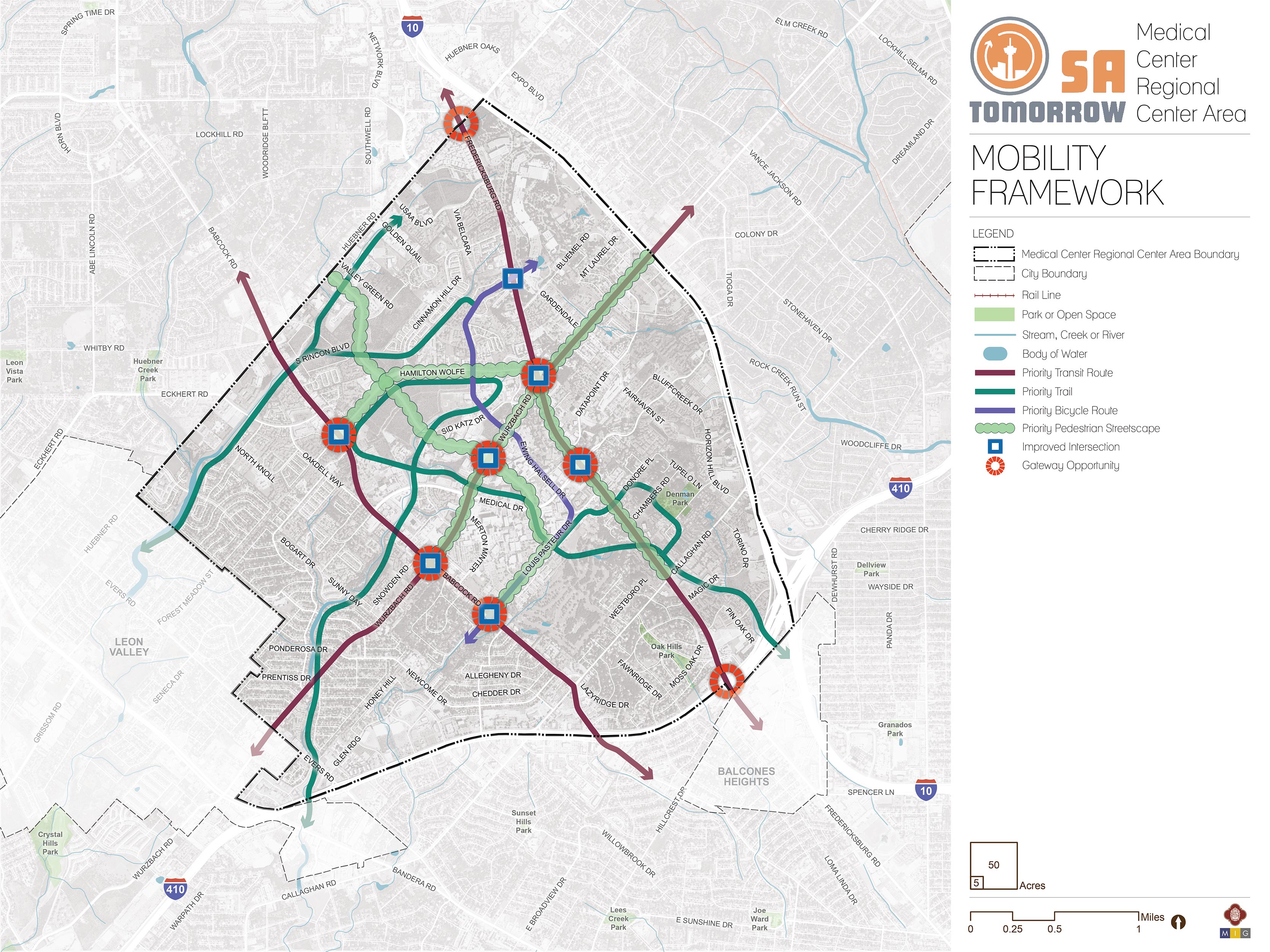
The map below highlights the Mobility Framework identified for the Medical Center Area Regional Center. Scroll down to learn more about the vision for Mobility in the Plan Area.
To provide specific feedback on the map, please click and drag a box on that location of the map and fill out the comment box. We would love to hear more from you!
You can also visit the bottom of the page to leave additional feedback.
Recommendation #1:
Continue Implementing the San Antonio Vision Zero Action Plan.The City of San Antonio’s Vision Zero initiative aims to achieve zero fatalities on the community’s roadways and improve roadway safety for all users, whether driving, bicycling, or walking. The Vision Zero initiative evaluates and makes recommendations to improve safety in Severe Pedestrian Injury Areas (SPIAs), locations where two or more crashes close together have resulted in severe pedestrian injuries. Potential tools for improving pedestrian safety in Severe Pedestrian Injury Areas include Leading Pedestrian Intervals, Medians, and Pedestrian Crossing Islands based upon analysis of the unique factors that contribute to crashes in each location and depending upon the results of engineering assessments. Another approach to improve safety involves dedicating more space in the roadway to bicyclists and pedestrians. From new ways to protect bicycle lanes with separated barriers such as bollards, to landscaping and planters and raised medians, San Antonio has many available tools to improve pedestrian and bicycle safety. The City of San Antonio Vision Zero Action Plan lists additional tools for improving pedestrian and bicycle safety.
The Medical Center Area has a wealth of opportunities for improving transportation and safety. Transportation investments that focus on safety, such as improving crossings and investing in complete streets can have a significant positive impact throughout the Medical Center Area Regional Center. In particular, the 2018 San Antonio Severe Pedestrian Injury Areas Report (pages 37-40) identifies six Severe Pedestrian Injury Areas (SPIAs) within or adjacent to the Medical Center Area Regional Center that should be priorities for study and investment:
- Babcock Road from Snowden Road to Merton Minter;
- Callaghan Road from Horizon Hill Boulevard to Rock Creek Run Street;
- Fredericksburg Road from Bluemel Road to Cliff Oaks;
- Fredericksburg Road from Magic Drive to Lakeridge Drive;
- Wurzbach Road from Fredericksburg Road to Blumel Road; and
- Wurzbach Road from Von Scheele Drive to Medical Drive.
Additional analysis of pedestrian, bicycle, and vehicle crash data, along with community input, also identified additional points of conflict between people and vehicles that should be studied for future improvements. Major highways, such as Interstate-10 (I-10) and Loop 410, and their associated frontage roads, create barriers for many pedestrians and bicyclists. The unwelcoming environment of fast speeds and limited amenities limits travel options for those walking or bicycling. Major roadways, like Fredericksburg Road, Wurzbach Road, Callaghan Road, Babcock Road, and Huebner Road have insufficient accommodations and less than ideal conditions for pedestrians and bicycles to travel on and cross safely. In addition, numerous driveways create many potential conflict points between automobiles, pedestrians, and bicycles. Employing strategies to reduce these points of conflict can increase safety in the study area.
Investments that focus on safety, such as the Vision Zero tools listed above, can have a significant positive impact throughout the Medical Center Area, and especially in these identified conflict areas. Reducing speeds in appropriate areas can also greatly improve safety for all users, by reducing the likelihood and intensity of crashes.
Recommendation #2:
Complete the multi-modal layered network and trail system and work with partners to establish new connections.Multimodal and connected networks are key aspects to providing mobility for all users, regardless of ability or financial status. Transit improvements ensure areas are accessible while bicycle and pedestrian infrastructure provide last-mile connections to and from transit and key destinations. Urban design elements, such as driveway relocation, street calming, and complete streets, further support these improvements while providing safe and inviting spaces.
Complete Streets
Complete streets are envisioned for the Medical Center Area Regional Center, providing safe road designs for vehicles, pedestrians and cyclists alike. The following streets are recommended for TCI to study for complete streets improvements:
- Fredericksburg Road from Loop 410 to Wurzbach Road;
- Wurzbach Road from Babcock Road to I-10;
- Louis Pasteur Drive from Babcock Road to Floyd Curl Drive; and
- Hamilton Wolfe Road from Babcock Road to Fredericksburg Road.
These streets will also connect to recreational trails and parks, such as the existing South Texas Medical Center Foundation trails, and the nearby regionally significant Leon Vista Trailhead of the Leon Creek Greenway.
Priority Streetscape Improvements
Streetscape improvements are also being recommended for corridors including:
- Floyd Curl Drive from Huebner Road to Louis Pasteur Drive;
- Hamilton Wolfe Road from Babcock Road to Fredericksburg Road;
- Wurzbach Road from Babcock Road to I-10;
- Louis Pasteur Drive from Babcock Road to Floyd Curl Drive; and
- Fredericksburg Road from Callaghan Road to Wurzbach Road.
A vision for these corridors is one where people walking, biking, taking transit or rideshare, or driving brings street-level activity that creates safer and more vibrant streets.
Priority Trails
Key trails nearby or within the Medical Center Area Regional Center, like the existing San Antonio Medical Foundation trails and Leon Vista Trailhead of the Leon Creek Greenway, provide critical continuous arteries of separated pedestrian and bicycling infrastructure network, connecting numerous parks, retail locations, schools, and libraries. The critical access points to these regional amenities provide opportunities to improve connections for people walking, strolling or bicycling with deliberate side paths or on-road infrastructure like crosswalks, sidewalks and bicycle facilities.
Preferred Bicycle Routes
In many parts of the Medical Center Area, bicyclists currently ride in mixed-traffic on high-speed and high-volume roads. Additional bike infrastructure, such as designated lanes, is highly recommended where feasible and as part of complete streets and other improvement projects. These measures will improve riding conditions for today’s commuters and welcome newer, less confident bicyclists, otherwise unaccustomed to riding alongside vehicles. The provision of bicycle parking and bike share at transit stops provides an important connection for people wanting to access transit by bicycle and helps to address the ‘last mile’ challenge, helping people connect from their destinations to and from transit.
Based on input from the Medical Center Area Planning Team and other community stakeholders, the plan identifies priority bicycle routes for the Medical Center Area including:
- Floyd Curl Drive from Huebner Road to Fawn Meadows;
- Wurzbach Road from Medical Drive to Evers Road;
- Eckhert Road from Huebner Road to Babcock Road; and
- Callaghan Road from Fredericksburg Road to Pinebrook Drive.
Corridors identified for complete streets along Fredericksburg Road, Wurzbach Road, Louis Pasteur Drive, and Hamilton Wolfe Road would also incorporate cycling infrastructure as a component of the design based on future studies by TCI to determine feasibility and the types of facilities needed.
Recommendation #3:
Manage transportation demand by creating walkable places and by supporting efficient vehicular flow and transit operations through targeted interventions.Shifting users from driving alone to alternative modes of transportation can alleviate congestion along a corridor or within an area. This becomes more viable when alternatives are convenient, such as through improved access to transit and pedestrian-friendly infrastructure. This strategy directly supports the community's, City’s, and VIA’s goals and objectives, by improving access to key destinations, decreasing vehicle miles traveled, and increasing the area’s walkability. To support growth and continue the vibrancy of the region’s economic centers, the community needs easy, reliable, and congestion-proof choices for traveling to and from work, school, and key destinations.
While congestion can be viewed as a sign of economic health, delays caused by congestion waste valuable time and create transportation emissions that reduce air quality. The transportation industry has learned ‘we cannot build our way out of congestion’, however a series of targeted operational and multimodal interventions can provide more travel options and reduce the demand on our roadways. Key investments to reduce congestion and conflict zones that delays transit can help transit move more rapidly on San Antonio’s roadways and stay on schedule. These improvements, paired with other VIA Metropolitan Transit investments in service, can help make transit a more attractive travel option. This recommendation is responsive to the Sub-Area Plan’s community goal of “Enhanced Mobility Options” and the SA Tomorrow Comprehensive Plan’s Transportation and Connectivity Goals. These strategies can support the vibrancy of the region’s economic centers, by connecting residents with easy, reliable, and congestion-proof choices to and from work, school, and key destinations.
Key improvements that could improve transit mobility include peak hour or school zone bus-only lanes that give priority to buses in times of peak traffic; queuing jump traffic signals to allow buses a chance to get ahead of the traffic; special event priority lanes that give priority to buses during traffic surges of planned events; and bus bulbs to allow buses to pick up passengers without entering/exiting traffic. Studies will need to be conducted to determine the appropriateness for each strategy for the areas of local congestion.
As indicated on the Mobility Recommendations Map, the priority locations for more study include:
- Wurzbach Road and Fredericksburg Road;
- Loop 410 Frontage Roads from I-10 to Evers Road;
- Fredericksburg Road from Loop 410 to Callaghan Road;
- Fredericksburg Road from USAA Boulevard to Huebner Road;
- Babcock Road from Wurzbach Road to Medical Drive;
- Wurzbach Road from Babcock Road to Medical Drive,
- Wurzbach Road from Gardendale to I-10; and
- Huebner Road from Research Drive to I-10.
Operational improvements to help with the flow of vehicular traffic include: comprehensively addressing the traffic signal upgrade program on major corridors; partnering to develop a subarea transportation management center; and developing a parking management strategy.
- Traffic signals upgrade – by addressing major corridors in the Medical Center Area in a comprehensive manner, improvements could help ease heavy congestion during both morning and afternoon peak periods.
- Subarea Transportation Management Center – a collaboration of Medical Center institutions to develop a virtual subarea Transportation Management Center (TMC) supports the unique needs of the Medical Center operations. Developed in partnership with the City’s Traffic Systems Management and Operations, TxDOT TransGuide, and VIA, a Medical Center TMC would provide a hub of real-time information for Medical Center travelers. A virtual TMC could allow information to be gathered automatically and transmitted to locations at each institution within the Medical Center. Some level of staffing is required, however, in order to allow actions to be taken in real time.
- Parking Management Strategies – by providing information on parking availability at key locations, as well as traffic conditions, and utilizing guide signs to help visitors find their way to desired parking areas, parking management solutions help route one-time or infrequent visitors to these parking areas more efficiently.
Recommendation #4:
Support VIA Metropolitan Transit Rapid Transit Corridor service by prioritizing transit supportive policies and infrastructure near transit stations.Two future VIA Metropolitan Transit Rapid Transit Corridors are anticipated to operate east-west on Wurzbach Road and north-south on Fredericksburg Road and Medical Drive require prioritized transit-supportive policies and infrastructure, such as reduced parking requirements, and cohesive networks of sidewalks, crosswalks and curb ramps improvements to provide safe connections to the transit lines for people walking, bicycling, or getting dropped off in a vehicle.
Providing last mile connections between transit and key destinations, such as jobs and public spaces, improves mobility throughout the area while supporting walkability and safety for all transportation users. These improvements are outlined by the community’s goals and objectives for the Medical Center Area Regional Center and are applicable to the future rapid transit corridors operating east-west along Wurzbach Road, and north-south along Fredericksburg Road. Key components of VIA Metropolitan Transit’s approach of making a place transit-supportive are streets designed for pedestrians, improving the safety of all users, and supporting compact, mixed-use developments providing access to a variety of services reachable on foot.
Every person that gets on or off a bus or other transit vehicle is a pedestrian. Safe, comfortable and direct access to transit for people walking or biking to a transit station or stop will improve their experience as a transit rider and will increase the number of people choosing walking, bicycling, and taking transit as their preferred travel choice. These improvements also contribute to the overall quality of neighborhoods and communities.
Mobility Concepts
The recommendations in this plan will help create a user-friendly multi-modal network that provides access to amenities, link Medical Area employees, visitors, residents, and students to the greater San Antonio area and supports planned activity centers and land uses. The general concepts below serve as guiding principles for the more detailed Mobility Recommendations listed above.
Complete Streets
In September 2011, the City of San Antonio adopted a Complete Streets Policy (Ordinance 2011-09-29-0795) which encourages street designs that take into account all users and accommodate all ages and abilities including children, older adults, and persons with disabilities. This approach to street design “supports pedestrian and bicycle-oriented neighborhoods; promotes healthy living, fitness, and activity; enhances the economic vitality of commercial corridors and districts; and maximizes the benefits of investment in public infrastructure.” Not all “complete” streets have to be the same; the function of the road, level of traffic by mode, and adjacent land use and intensity will all be used to help determine road type and design features.
Complete Streets studies and subsequent implementation should take into account best practices from guidance provided in the National Association of City Transportation Officials (NACTO) Design Guidelines, and NACTO Transit Street Design Guide for roadways that will include VIA Primo or Rapid Transit Corridor Service. Improvements should also include lighting, landscaping, and green infrastructure where possible, and other placemaking features such as artistic elements. Implementing these policies and projects will ensure all people, regardless of income or ability, can access high-quality transportation services and can live car-free and access services, jobs and recreation.
Additional resources to implement strategies for better streets include: The Bicycle & Pedestrian Program of the Federal Highway Administration's Office of Human Environment (provides extensive bicycle and pedestrian resources and guidance); The Smart Growth America National Complete Streets Coalition; Complete Streets: Best Policy and Implementation Practices (based on the evaluation of 30 communities across the U.S.); and the Toolkit: Complete Streets in the Southeast (developed through a partnership amongst AARP Government Affairs, Smart Growth America, and the National Complete Streets Coalition.
Priority Bicycle Routes and Streetscape Improvements
Encouraging walking and biking within a Regional Center as convenient, safe, and comfortable options will require an integrated network of pedestrian and bicycle routes along with well-designed streets in key activity areas. Today, there are gaps in the multi-modal system serving the Medical Center Area, especially for people wishing to walk or bike. This plan focuses on completing sidewalk and bicycle networks and recommends new connections that will help people travel east-west in the study area, and more directly access trails and other amenities.
Improved Pedestrian Crossings
Safety is central to planning for the Medical Center Area Regional Center’s development as a walkable center. Analysis of previous pedestrian crashes in this sub-area has identified roads segments most in need of additional pedestrian accommodations. Improved access to VIA Metropolitan Transit service is also a key factor for improving existing and locating new crossings.
Resources to implement strategies for intersections include the FHWA Office of Safety Proven Safety Countermeasures, http://safety.fhwa.dot.gov/provencountermeasures; NCHRP Report 500: Volume 12, A Guide for Reducing Collisions at Signalized Intersections; and NCHRP Report 500: Volume 5, A Guide for Addressing Unsignalized Intersection Collisions.
Dedicating more space in the roadway to bicyclists and pedestrians by adding landscaping, buffered sidewalks along the roadway can improve the level of comfort for vulnerable users. According to the FHWA, adding dedicated space for sidewalks results in a 65-89% reduction in crashes involving pedestrians walking along roadways. Bicycle and pedestrian facility design and materials have advanced considerably over the last decade. Many of San Antonio’s peers have tested and reported the results of new applications. From new ways to separate bicycle lanes with LED lit bollards, to landscaping and planters or raised medians or lanes, San Antonio has many options to implement the safety strategies in a way that meets the goals of the Medical Center Area Regional Center Plan to improve safety on the transportation system and improving walkability.
Resources to implement strategies for pedestrians and bicycles can be sourced from the City of San Antonio Vision Zero Action Plan, as well as national resources such as the NACTO Design Guide to Transit Corridors. For resources on proven approaches to crash reduction, see:
- The Federal Highway Administration Crash Reduction Factor Toolbox; National Highway Traffic Safety Administration. Countermeasures That Work: A Highway Safety Countermeasure Guide for State Highway Safety Offices, Seventh Edition, 2011. Washington, D.C.: U.S. Department of Transportation. 2013;
- NCHRP Report 500 Volume 18: A Guide for Reducing Collisions Involving Bicycles;
- Crash Modification Factors Clearinghouse;
- FHWA Proven Safety Countermeasures. Federal Highway Administration, Office of Safety, Washington, DC, 2012;
- Handbook for Designing Roadways for the Aging Population. Federal Highway Administration, Office of Safety, Washington, DC, 2014;
- Separated Bike Lane Planning and Design Guide; and
- The NACTO Urban Bikeway Design Guide (part of the Cities for Cycling initiative).
Frequent, Reliable, and Accessible Transit
Providing great transit service and a walkable environment allows users to choose travel options besides driving alone - alleviating a primary cause of congestion. Supporting alternative modes of transportation provides the community with easy, reliable, and congestion-proof choices for traveling to and from work, school, and key destinations and helps to fulfil the Medical Center Area’s Enhanced Mobility Options goal statements:
- Develop a multi-modal network that provides options for pedestrians, cyclists and public transit riders that provides stellar connectivity to other major employment hubs as well as the rest of the city;
- Encourage innovative traffic congestion solutions and parking management strategies; and
- Increase pedestrian safety through street design.
These strategies also alleviate congestion along corridors within the community and this becomes more viable when alternatives are convenient, such as through improved access to transit and pedestrian-friendly infrastructure.
VIA’s Rapid Transit Corridors will create additional transportation choices in the area with new investments in very frequent transit service that quickly move people to their destinations. This additional transit service will provide more direct connections between the Medical Center Area, Downtown, UTSA Area Regional Center, and the Stone Oak Area Regional Center. Studies are determining the exact routing and phasing of construction.
Complete streets and placemaking investments near transit corridors and access points are important to improve people’s ability to utilize transit through safe and pleasant community connections. In addition, future transit investments should be supported by transit supportive policies and infrastructure, such as reduced parking requirements, and a cohesive network of sidewalks, crosswalks, and curb ramp improvements that can provide safe connections to the transit line for people walking, bicycling, or getting dropped off in a vehicle.
Linked Mobility and Land Use
As communities evolve and grow, so do the demands on the mobility system. The location and type of growth in an area or along a corridor help determine the demand on the transportation network and the viability of various transportation options. Likewise, transportation helps shapes the desirability and type of development in an area. Aligning this relationship shapes future development and growth patterns and directly supports the community’s goals and objectives of improving walkability, increasing access to transit, and enhancing access to economic areas and other key destinations. Such alignment of land use and mobility also helps implement VIA’s 2040 Strategic Plan for Station Areas, supporting transit-supportive land use surrounding transit stations.
As the Medical Center Area Regional Center adds residents and employees based on the updated land use plan, impacts on the mobility needs of these new people and those of current employees, residents, and students need to be considered. Land uses encouraging mixed-uses and higher density developments are recommended along Wurzbach Road, Medical Drive, Fredericksburg Road, and Huebner Road. With these more intense land uses, these major roadways can anticipate additional pedestrians, bicyclists, transit riders, cars, and freight delivery trucks of various sizes. Studies will need to determine common paths and volumes of pedestrian, bicycle, automobile, transit, and freight travel to ensure the area has sufficient infrastructure and careful prioritization of modes to help people safely reach their destinations.
Gateway Opportunities
To build on the strong community identity of the Medical Center Area Regional Center, several places provide opportunities for unique gateways. Gateways provide a sense of place and welcome residents and visitors with art and architectural elements which reflect neighborhood history and culture.
There are several locations for gateways in the core of the Medical Center Area Regional Center. Gateways at Fredericksburg Road and Wurzbach Road, Wurzbach Road and Babcock Road, and Fredericksburg Road and Medical Drive are ideal locations to welcome visitors and residents and distinguish the Regional Center’s identity. The intersection of Medical Drive and Wurzbach Road provides a central location to create a public space and enhance the identity of the area.