Plan Framework
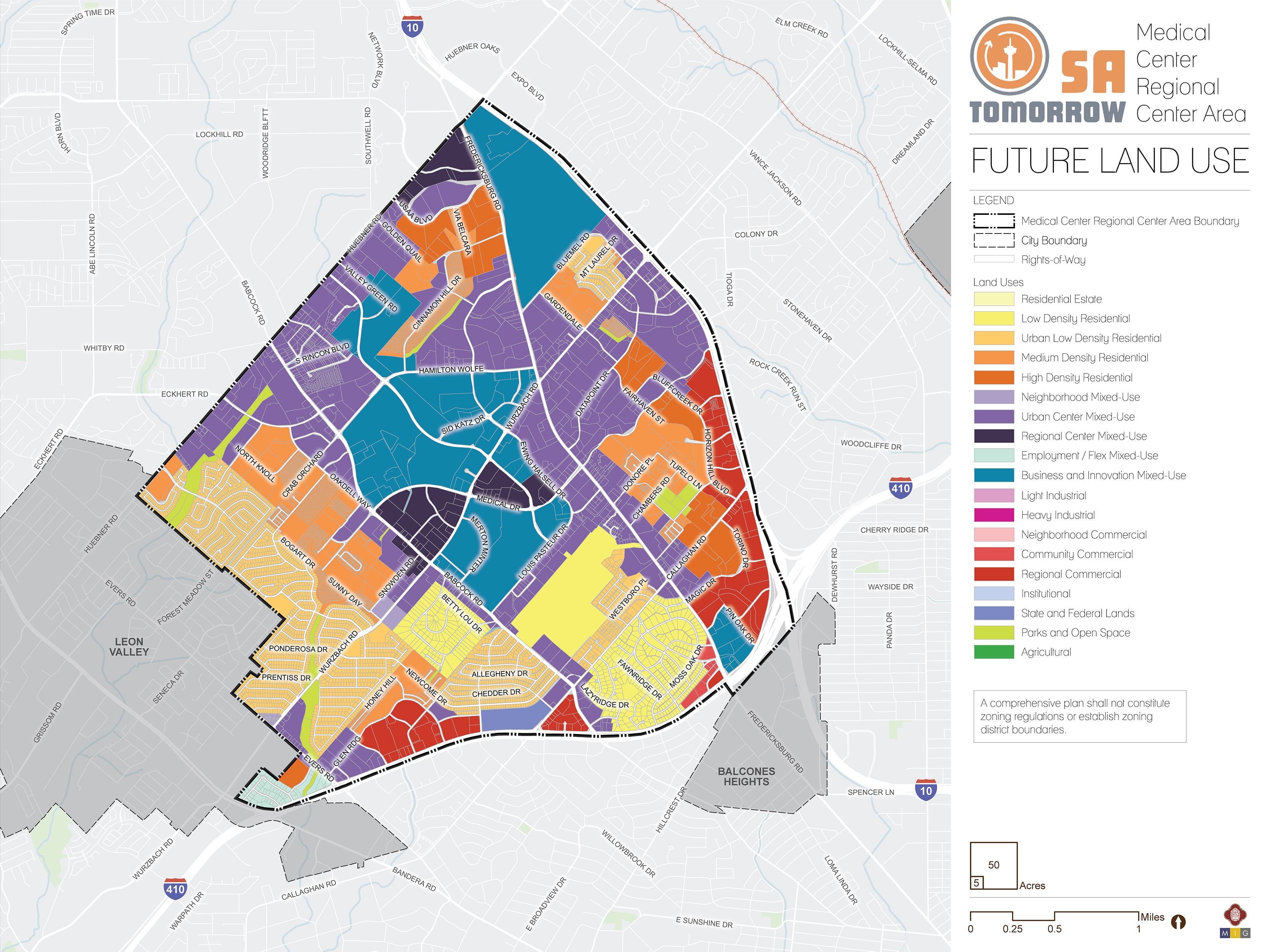
Land Use

The Medical Center Area Regional Center Land Use Plan supports the SA Tomorrow Comprehensive Plan, Multimodal Transportation Plan and Sustainability Plan. It also draws on recommendations from the SA Corridors Strategic Framework Plan and implements the Vision, Goals, and Plan Framework for the Medical Center Area. The Future Land Use Plan encourages growth and increased density at various scales in mixed-use centers and focus areas and along key transit and community corridors. It provides opportunity for higher density mixed-use associated with the major highways, but also preserves the character and form of existing neighborhoods. Growth along Interstate-10 (I-10) is designated as either commercial or as mixed-use, in keeping with the North Sector Plan already in place.
The following sections describe the general future land use patterns of the Medical Center Area. Recommendations for implementing the land use plan follow, and the full catalogue of land use categories (including descriptions and allowable zoning districts) adopted in the Unified Development Code (UDC) are found at the bottom of the page.
Land Use Recommendations
Four land use recommendations are identified to support the land use plan for the Medical Center Area. In the implementation section of the plan, specific strategies are provided for each of the following recommendations.
Recommendation #1:
Ensure that properties in areas designated as Regional Mixed-Use are zoned to accommodate a high intensity of development activity, so that they can serve as a hub for this regional center.SA Tomorrow designated 13 regional centers to help absorb a significant portion of projected population and employment growth over the next 20 years. This will require higher densities and a higher intensity of uses in the Medical Center Area. Much of this plan area is designated as Urban Mixed-Use or Regional Mixed-Use. After the plan is adopted, properties in the Regional and Urban Mixed-Use areas may need to be rezoned, in order to accommodate this growth.
Mixed-use projects and areas could be rezoned using existing Mixed-Use (MU), Transit-Oriented Development (TOD), or Form-Based Zoning (FBZD), or using future zoning districts that may be designed to correspond to these mixed-use areas. Setbacks, building heights and site design standards vary based on the context and planned intensity of use. Areas designated as Regional Mixed-Use in the center of this plan area have the capacity to absorb a considerably higher level of density than other mixed-use areas, especially those that provide a transition to, or directly serve, lower density residential areas.
Recommendation #2:
Examine the zoning of properties at the southwestern tip of the plan area and rezone if necessary, to allow uses appropriate for the Employment/Flex Mixed-Use designation.Employment/Flex Mixed-Use allows for an integration of a broad range of uses, including some industrial uses with storefront space and with residential uses. This encourages a flexible live/work environment with an urban mix of residential and light service industrial uses. Rezoning may be needed to ensure that this type of environment can be achieved. Currently, most of the properties in the Employment/Flex Mixed-Use area in the southwest corner of the Medical Center plan area are zoned for industrial and commercial use. Though commercial uses are permitted for the Employment/Flex Mixed-Use category, other zoning designations may be helpful in encouraging desired uses and urban form, such as IDZ districts or other new mixed-use zoning districts developed in the future.
The southwest corner of the plan area intersects with the ongoing Bandera Road Corridor Plan at the Loop 410 and Bandera Road intersection; land use recommendations from the Medical Center Area Regional Center Plan should guide land use decisions for this portion of the Corridor Plan.
Recommendation #3:
Ensure properties in Medium and High Density Residential areas to ensure that this regional center is able to absorb projected future population growth.Land Use designations in the Medical Center Area need to accommodate forecasted population changes and maximize its ability to absorb future growth. To this end, it will also be important to ensure that properties in Medium and High Density Use areas are zoned appropriately. This may require rezoning to a higher level of residential density for multi-family areas. Strategic upzoning of multi-family properties can also help to stimulate revitalization and redevelopment of older properties, making this a more competitive area for new projects.
Recommendation #4:
Promote and preserve higher intensity commercial uses, such as office buildings, hotels, and larger retail centers along the I-10 frontage.The properties near the intersection of Loop 410 and I-10 can support higher levels of density based on available infrastructure and the regional reach of these two highways. It is important not to permit uses in this area that do not capture the value associated with this location. Regulatory tools and incentives should be put in place that preserve the value potential of this area and encourage appropriate redevelopment.
Residential Areas
The Medical Center Area Regional Center contains a broad range of housing options, especially compared to other parts of San Antonio. The largest concentrations of residential uses are focused in the southern portion of the plan area, southwest of Babcock Road and southeast of Louis Pasteur Drive. Several pockets of higher density housing are also found north and east of the Medical Center campus.
Most of the neighborhoods south of the Medical Center campus are established, and generally built out. They are classified as Low Density Residential or Urban Low Density Residential. The Oak Hills Neighborhood, Dreamhill Esates Neighborhood and a few others are classified as Low Density Residential, whereas the majority of the other neighborhoods are classified as Urban Low Density Residential, due to smaller lot sizes. Urban Low Density areas also allow a broader variety of housing options, such as duplexes, compact lot single family units and bungalow courts. They also permit neighborhood commercial uses. All of the neighborhoods along the southwest edge of the plan area are designated Urban Low Density Residential, as is the area south of the Oak Hills Country Club. There is also a pocket of Urban Low Density Residential north of Wurzbach Road and just west of I-10. This area, although composed of predominantly single-family residential properties, is surrounded by higher density uses, and needs to be able to accommodate a higher level of density than some of the other single family areas in this regional center.
Multi-family and higher density single family properties are generally classified as Medium Density Residential or High Density Residential. Medium Density Residential is generally used to designate townhomes, duplexes, triplexes, and other “missing middle housing”, as well as multi-family properties such as apartments and condominiums that are only a few stories in height. There are three general areas where land has been classified as Medium Density in this planning area: west of Oakdell Way/Babcock Road, the Preston Peak area south of Medical Drive and west of Fairhaven Street, and along Cinnamon Hill Drive, between Gus Eckert Road and Hamilton Wolfe Road. High Density Residential is used to classify properties with an even higher density of units, typically in taller buildings. These higher density areas are helpful in absorbing anticipated population growth, which is one of the goals of a regional center. High Density Residential properties are found along Gus Eckert Road, south of USAA Boulevard and west of Fredericksburg Road. There are also pockets of High Density Residential behind the designated Regional Commercial areas fronting I-10, along Callaghan Road and also along Horizon Hill Boulevard. High Density Residential is typically sited close to regional-scale commercial and mixed-use development, due to comparable traffic impacts and intensity of use and activity.
Mixed-Use Centers and Corridors
The Medical Center Area Regional Center land use plan encourages more dense and intense land uses in appropriate areas including mixed-use centers, designated focus areas and primary corridors. Each mixed-use area should have different qualities, design, and intensity based on surrounding uses, the type of the roadways in the area, and the amount of available land. The land use plan accounts for this by utilizing three different mixed-use categories, each of which encourages a different mix of allowable uses, density, and intensity, thus promoting developments that best serve the needs of, and complement, the surrounding areas. Mixed-use areas can also support appropriate transitions to adjacent neighborhoods while spurring local economic vitality. In the Medical Center Area, there are mixed-use designations at different scales, including neighborhood mixed-use, urban mixed-use, and regional mixed-use. All mixed-use areas prioritize pedestrian and bicycle access, and the creation of great public spaces. Mixed-use areas are also intended to support various levels of transit service based on density and expected level of activity.
Regional Mixed-Use
The Regional Mixed-Use areas are intended to be centers with the highest intensity of uses and activity, serving nearby neighborhoods and regional interests alike. The residential components of projects in these areas are typically high density, incorporating first floor retail and commercial uses. A Regional Mixed-Use area is intended to serve as a hub for transportation and mobility, and as a value reference point for surrounding properties and future development. There are two areas designated as Regional Mixed-Use in this planning area: at the very center of the plan area, along Wurzbach Road and Medical Drive, and along the northwestern boundary of the plan area, near Fredericksburg Road and Huebner Road.
Urban Mixed-Use
Urban Mixed-Use is the predominant land use designation in this plan area. Urban Mixed-Use integrates residential and commercial uses, creating walkable places with access to transit and a variety of active uses throughout the day. Most of Fredericksburg Road frontage properties are classified as Urban Mixed-Use, as are those along Huebner Road and Wurzbach Road east of Fredericksburg Road. Smaller pockets of Urban Mixed-Use can be found along other major roads within the plan area.
Neighborhood Mixed-Use
Neighborhood Mixed-Use is designated only in two places within the Medical Center plan area, both along Wurzbach Road. The first is at the intersection of Wurzbach Road and Evers Road. The second is along Wurzbach Road at Tourant Road, including the Woodland Ridge Apartments and the two churches on the northern side of the road. The density and intensity for Neighborhood Mixed-Use is lower than in Urban or Regional Mixed-Use, though a broad mixture of uses is permitted. These areas generally have smaller buildings and a lower level of activity, amenities, and transit service. The focus is on service to immediately adjacent neighborhoods, providing walkable areas at a scale that complements surrounding neighborhood development. This classification also serves as a transition between neighborhoods and higher intensity uses.
Commercial Areas
Commercial areas of the Medical Center Area are classified as either Regional Commercial or Community Commercial. These areas are designated for purely commercial uses, including existing and potential shopping centers. Regional Commercial areas are found along I-10 and Loop 410. These are large-scale commercial projects that generate a higher traffic demand and have larger lot sizes. Community Commercial is the designation for areas allowing strictly commercial uses, but with less intensity of use and of traffic generation. The only portion of the plan area designated as Community Commercial is near the intersection of Loop 410 and Fredericksburg Road.
Employment Areas
While designated mixed-use and commercial areas will support a variety of businesses and employment opportunities, there are three land use designations in this area that typically have a significant impact on employment: Business/Innovation Mixed Use, Employment/Flex Mixed-Use and City, State and Federal Government Uses.
The Texas Department of Transportation (TxDOT) San Antonio District Headquarters, located along Loop 410 west of Babcock Road, is the only City/State/Federal Government Property in the plan area. It is bound on both sides along Loop 410 by Regional Commercial uses, and the neighborhood behind it is designated as Urban Low Density Residential.
Land designated as Employment/Flex Mixed-Use is intended to allow for a broad range of permitted uses, so that industrial, commercial and residential uses can be compatibly integrated at a small to mid-scale project. This would allow for adaptive re-use of older industrial or tech flex properties for creative work spaces, cottage industrial or fabrication uses, and residential uses including live-work lofts with apartments located above work spaces. Property to the north of the intersection of Loop 410 and Bandera Road has been designated as Employment/Flex.
The majority of the property within the area formally designated as Medical Center is designated as Business/Innovation Mixed-Use. Data centers, technological learning centers, medical campuses, and research/development institutions are appropriate for these spaces. Properties classified in this way are often larger parcels, and many have higher security and power requirements than other forms of mixed-use. Other areas classified as Business/Innovation Mixed-Use include the USAA campus and the properties at the southeast corner of the Loop 410 and Fredericksburg Road intersection.
Parks and Open Spaces
Properties designated as Parks and Open Spaces serve recreational and environmental purposes for the Medical Center Area. Uses include trails, city parks, recreational fields, and riparian areas. Land along Huebner Creek and Zarzamora Creek is designated as Park and Open Space, as is Denman Estate Park, the Rock Creek drainage easement near Wurzbach Road and Gardendale, and the Cinnamon Creek drainage easement.
Future Land Use Categories
As described above, the Medical Center Area Regional Center Plan includes a range of land use designations that represent the unique character of the area, while encouraging and supporting development patterns that reflect the goals of the SA Tomorrow Comprehensive Plan and the preferences of the Medical Center Area community. Listed below is the full list of land use categories adopted by City Council into the Unified Development Code (UDC), Chapter 35, on October 11, 2018. Each category listed includes a description, general guidance on where the land use designation is most appropriate, and a list of allowable zoning districts.
Residential Estate
Residential Estate includes large lot single-family detached houses on individual estate-sized lots or in conservation subdivisions. This form of development should be located away from major arterials, and can include certain nonresidential uses such as schools, places of worship, and parks that are centrally located for convenient neighborhood access. Permitted zoning districts: FR, R-20, RE, and RP.
Typical densities in this land use category would be up to 2 dwelling units per acre.
Low Density Residential
Low Density Residential includes single-family detached houses on individual lots, including manufactured and modular homes. This form of development should not typically be located adjacent to major arterials. This land use category can include certain nonresidential uses such as schools, places of worship, and parks that are centrally located for convenient neighborhood access. Permitted zoning districts: R-4, R-5, R-6, NP-8, NP-10, and NP-15.
Typical densities in this land use category would range from 3 to 12 dwelling units per acre.
IDZ and PUD may be considered consistent with this land use category, provided the permitted uses included on the zoning site plan and zoning ordinance are consistent with the uses and densities outlined above.
Urban Low Density Residential
Urban Low Density Residential includes a range of housing types including single-family attached and detached houses on individual lots, small lot residences, duplexes, triplexes, fourplexes, cottage homes, manufactured homes, low-rise garden- style apartments, and manufactured home parks. This land use category may also accommodate small scale retail and service uses that are intended to support the adjacent residential uses. Other nonresidential uses, including, but not limited to, schools, places of worship, and parks are appropriate within these areas and should be centrally located to provide easy accessibility. Permitted zoning districts: R-3, R-4, R-5, R-6, RM-5, RM-6, MF-18, MH, MHC, MHP, and NC.
Typical densities in this land use category would range from 7 to 18 dwelling units per acre. IDZ, PUD, MXD, and TOD may be considered consistent with this land use category, provided the permitted uses included on the zoning site plan and zoning ordinance are consistent with the uses and densities outlined above.
Medium Density Residential
Medium Density Residential accommodates a range of housing types including single-family attached and detached houses on individual lots, manufactured and modular homes, duplexes, triplexes, fourplexes, and low-rise, garden-style apartments with more than four (4) dwelling units per building. Cottage homes and very small lot single-family houses are also appropriate within this land use category. Higher density multi-family uses, where practical, should be located in proximity to transit facilities. Certain nonresidential uses, including, but not limited to, schools, places of worship, and parks are appropriate within these areas and should be centrally located to provide easy accessibility. Permitted zoning districts: R-3, R-4, RM-4, RM-5, RM-6, MF-18, MF-25, MF-33, MH, MHC, and MHP.
Typical densities in this land use category would range from 13 to 33 dwelling units per acre. IDZ, PUD, MXD, and TOD may be considered consistent with this land use category, provided the permitted uses included on the zoning site plan and zoning ordinance are consistent with the uses and densities outlined above.
High Density Residential
High Density Residential includes low-rise to mid-rise buildings with four (4) or more dwelling units in each. High density residential provides for compact development including apartments, condominiums, and assisted living facilities. This form of development is typically located along or near major arterials or collectors. High density multi-family uses should be located in close proximity to transit facilities. Certain nonresidential uses, including, but not limited to schools, places of worship, and parks are appropriate within these areas and should be centrally located to provide easy accessibility. This classification may be used as a transitional buffer between lower density residential uses and nonresidential uses. High density residential uses should be located in a manner that does not route traffic through lower-density residential uses. Permitted zoning districts: RM-4, MF-25, MF-33, MF-40, MF-50, MF-65, MH, MHC, and MHP.
Typical densities in this land use category would range from 25 to 50 dwelling units per acre. IDZ, PUD, MXD, and TOD may be considered consistent with this land use category, provided the permitted uses included on the zoning site plan and zoning ordinance are consistent with the uses and densities outlined above.
Neighborhood Commercial
Neighborhood Commercial includes smaller intensity commercial uses such as small-scale retail or offices, professional services, and convenience retail and services that are intended to support the adjacent residential uses. Neighborhood commercial uses should be located within walking distance of neighborhood residential areas. Special consideration should be given to pedestrian and bicycle facilities that connect neighborhoods to commercial nodes. Permitted zoning districts: O-1, NC, and C-1.
IDZ, PUD, MXD, TOD, and MPCD may be considered consistent with this land use category, provided the permitted uses included on the zoning site plan and zoning ordinance are consistent with the uses and densities outlined above.
Community Commercial
Community Commercial includes offices, professional services, and retail uses that are accessible to bicyclists and pedestrians and linked to transit facilities. This form of development should be located in proximity to major intersections or where an existing commercial area has been established. Community commercial uses are intended to support multiple neighborhoods, have a larger market draw than neighborhood commercial uses, and attract patrons from the neighboring residential areas. All off-street parking and loading areas adjacent to residential uses should include landscape buffers, lighting and signage controls. Examples of community commercial uses include, but are not limited to, cafes, offices, restaurants, beauty parlors, neighborhood groceries or markets, shoe repair shops and medical clinics. Permitted zoning districts: O-1.5, NC, C-1, and C-2.
IDZ, PUD, MXD, TOD, and MPCD may be considered consistent with this land use category, provided the permitted uses included on the zoning site plan and zoning ordinance are consistent with the uses and densities outlined above.
Regional Commercial
Regional Commercial includes high intensity uses that draw customers from both adjacent communities as well as the larger metropolitan region. Regional commercial uses are typically located in general proximity to nodes along expressways or major arterial roadways and incorporate high-capacity transit facilities. Regional Commercial uses should incorporate well-defined entrances, shared internal circulation, limited curb cuts to expressways and arterial streets, sidewalks and shade trees in parking lots, landscaping between the parking lots and roadways, and well- designed monument signage. Examples of regional commercial uses include, but are not limited to, movie theaters, plant nurseries, automotive repair shops, fitness centers, home improvement centers, hotels and motels, mid- to high-rise office buildings, and automobile
dealerships. Permitted zoning districts: O-1.5, O-2, C- 2, C-3, L, and BP.</p>IDZ, PUD, MXD, TOD and MPCD may be considered consistent with this land use category, provided the permitted uses included on the zoning site plan and zoning ordinance are consistent with the uses and densities outlined above.
Neighborhood Mixed-Use
Neighborhood Mixed-Use contains a mix of residential, commercial, and institutional uses at a neighborhood scale. Within mixed-use buildings, residential units located above first floor are encouraged. Typical first floor uses include, but are not limited to, small office spaces, professional services, and small scale retail establishments and restaurants. The mix of uses may be vertically or horizontally distributed, and there is no requirement that a single building contain more than one use. Live/work housing options are permissible in Neighborhood Mixed-Use area to ensure access to housing options and services within close proximity for the local workforce. Where practical, buildings are situated close to the public right-of-way, and parking is located behind buildings. Parking requirements may be minimized using a variety of creative methods, such as shared or cooperative parking agreements, to maximize land available for housing and community services. Pedestrian spaces are encouraged to include lighting and signage, and streetscaping should be scaled for pedestrians, cyclists, and vehicles. Properties classified as Neighborhood Mixed-Use should be located in close proximity to transit facilities. Permitted zoning districts: RM-4, RM-5, RM-6, MF-18, O-1, NC, C-1, MH, MHC, MHP, FBZD, AE-1, and AE-2.
IDZ, PUD, MXD, TOD and MPCD may be considered consistent with this land use category, provided the permitted uses included on the zoning site plan and zoning ordinance are consistent with the uses and densities outlined above.
Urban Mixed-Use
Urban Mixed-Use contains a mix of residential, commercial, and institutional uses at a medium level of intensity. Urban Mixed Use development is typically larger-scale than Neighborhood Mixed-Use and smaller-scale than Regional Mixed-Use, although many of the allowable uses could be the same in all three categories. Building footprints may be block-scale, but could be smaller depending on block configuration and overall development density. Typical first floor uses include, but are not limited to, professional services, offices, institutional uses, restaurants, and retail including grocery stores. The mix of uses may be vertically or horizontally distributed, and there is no requirement that a single building contain more than one use. Live/work housing options are permissible in Urban Mixed-Use areas to ensure access to housing options and services within close proximity for the local workforce. Structured parking is encouraged in Urban Mixed-Use category, but is not required. Parking requirements may be satisfied through shared or cooperative parking agreements, which could include off-site garages or lots. The Urban Mixed-Use category should be located in proximity to transit facilities. Permitted zoning districts: RM-4, RM-5, RM-6, MF-18, MF-25, MF-33, MF-40, O-1, O-1.5, C-1, C-2, MH, MHP, MHC, FBZD, AE-1, AE-2, AE-3, and AE-4.
IDZ, PUD, MXD, TOD and MPCD may be considered consistent with this land use category, provided the permitted uses included on the zoning site plan and zoning ordinance are consistent with the uses and densities outlined above.
Regional Mixed-Use
Regional Mixed Use contains residential, commercial and institutional uses at high densities. Regional Mixed-Use developments are typically located within regional centers and in close proximity to transit facilities, where mid-rise to high-rise buildings would be appropriate. Typical lower floor uses include, but are not limited to, offices, professional services, institutional uses, restaurants, and retail including grocery stores. The mix of uses may be vertically or horizontally distributed, and there is no requirement that a single building contain more than one use. Live/work housing options are permissible in Regional Mixed-Use areas to ensure access to housing options and services within close proximity for the local workforce. Where feasible, development is ideally built at the block scale, with minimum building setbacks. Parking requirements may be satisfied through shared or cooperative parking agreements, which can include off-site garages or lots. If parking requirements are satisfied on-site, structured parking is encouraged. Pedestrian spaces are encouraged to be generous in width and lighting, with streetscaping and signage scaled to pedestrians. Regional Mixed Use projects encourage incorporation of transit facilities into development. Permitted zoning districts: MF-33, MF-40, MF-50, MF-65, O-1.5, O-2, C-2, C-3, D, ED, FBZD, AE-1, AE-2, AE-3, and AE-4.
IDZ, PUD, MXD, TOD and MPCD may be considered consistent with this land use category, provided the permitted uses included on the zoning site plan and zoning ordinance are consistent with the uses and densities outlined above.
Employment/Flex Mixed-Use
Employment/Flex Mixed-Use provides a flexible live/work environment with an urban mix of residential and light service industrial uses. Uses include smaller-scale office, retail, art studio warehouses, art-oriented fabrication, creative businesses and work spaces, and cottage industrial and fabrication uses. Adaptive uses of vacant or underutilized structures are encouraged to provide residential urban infill and appropriate employment opportunities within or in close proximity to neighborhoods. Buildings have a smaller footprint and can closely resemble campus-like development across multiple sites or with several multi-functioning buildings on one site. Permitted zoning districts: RM-4, MF-18, MF-25, MF-33, O-1, O-1.5, C-1, C-2, L, AE-1, AE-2, AE-3, and AE-4.
IDZ, PUD, MXD, TOD and MPCD may be considered consistent with this land use category, provided the permitted uses included on the zoning site plan and zoning ordinance are consistent with the uses and densities outlined above.
Business/Innovation Mixed-Use
Business/Innovation Mixed-Use accommodates industrial uses with office, commercial, and residential uses, all within a cohesive setting, on a larger scale and within larger footprints than the Employment/Flex Mixed-Use category. Industrial arts workshops, high tech fabrication, processing and assembly, and other industrial uses are permitted, in addition to commercial uses. Vocational training, technological learning centers, medical campuses, and research/development institutions are also appropriate for these spaces. Additional environmental performance standards should be employed for properties designated as Business/Innovation Mixed-Use, such as hours of activity, loading, noise levels and lighting, to ensure that the intensity of the industrially oriented uses is comparable to that of the other non-residential uses. The mix of uses may be either vertically or horizontally distributed. Live/work housing options are permissible in Business/Innovation Mixed Use areas to ensure access to housing options and services within close proximity of business innovation areas for the local-workforce. Business/Innovation mixed use should incorporate transit and bicycle facilities to serve the training and employment base. Permitted zoning districts: RM-4, MF-18, MF-25, O-1.5, O-2, C-2, C-3, L, I-1, MI-1, BP, AE-1, AE-2, AE-3, and AE-4.
IDZ, PUD, MXD, TOD and MPCD may be considered consistent with this land use category, provided the permitted uses included on the zoning site plan and zoning ordinance are consistent with the uses and densities outlined above.
Light Industrial
Light Industrial includes a mix of manufacturing uses, business park, and limited retail/service uses that serve the industrial uses. Industrial uses should be screened and buffered from adjoining non-industrial uses. Any outside storage should be under a roof and screened from public view. Examples of light industrial uses include drug laboratories, furniture wholesalers, lumberyards, food production, and warehousing. Permitted zoning districts: L, I-1, MI-1, and BP.
IDZ, TOD, and MPCD may be considered consistent with this land use category, provided the permitted uses included on the zoning site plan and zoning ordinance are consistent with the uses and densities outlined above.
Heavy Industrial
Heavy Industrial includes heavy manufacturing, processing and fabricating businesses. Heavy industrial uses shall be concentrated at arterials, expressways, and railroad lines. This category is not compatible with neighborhood-scaled categories or those that permit residential zoning. Heavy Industrial should be separated from non-industrial uses by an allowable land use or a significant buffer. Examples of heavy industrial uses include auto manufacturing, battery manufacturing, and petrochemical bulk storage. Permitted zoning districts: I-1, I-2, MI-1, MI-2, QD, and SGD.
Agricultural
Agricultural includes crop agriculture, ranching, and related agribusiness practices. Single-family detached houses and detached accessory dwelling units are permitted on agricultural and ranch lands at very low densities or in conservation subdivisions that will not interfere with agricultural operations. Limited commercial uses directly serving agricultural and ranching uses, such as farmers markets, nurseries, stables, bed and breakfasts are permitted. To maintain scenic qualities, natural vegetative buffers, deeper setbacks, increased signage control, earthen drainage channels, and more restrictive access management standards are desired along major scenic corridors. Floodplain protection and buffer zones along creeks and rivers are instrumental in retaining rural character. Permitted zoning districts: RP and FR.
Parks/Open Space
Parks/Open Space may include, but is not limited to, large, linear, or unimproved land where conservation is promoted, and development is not encouraged due to the presence of topographic constraints or institutional uses on the site. Parks/Open Space may include utility corridors and public or private land uses that encourage outdoor passive or active recreation. Examples include city owned and/or operated pocket, regional, or linear parks, as well as private parks associated with subdivisions and neighborhood associations.
City/State/Federal Government
City/State/Federal Government includes areas owned and operated by a federal, state, or city agency. Examples may include government offices, public service facilities such as libraries and police stations, military bases, state colleges, and federal courts. This category does not apply to properties owned by a public agency but leased to and operated by another party.