Plan Framework
Amenities & Infrastructure
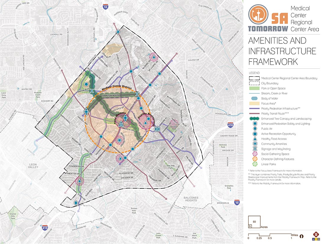
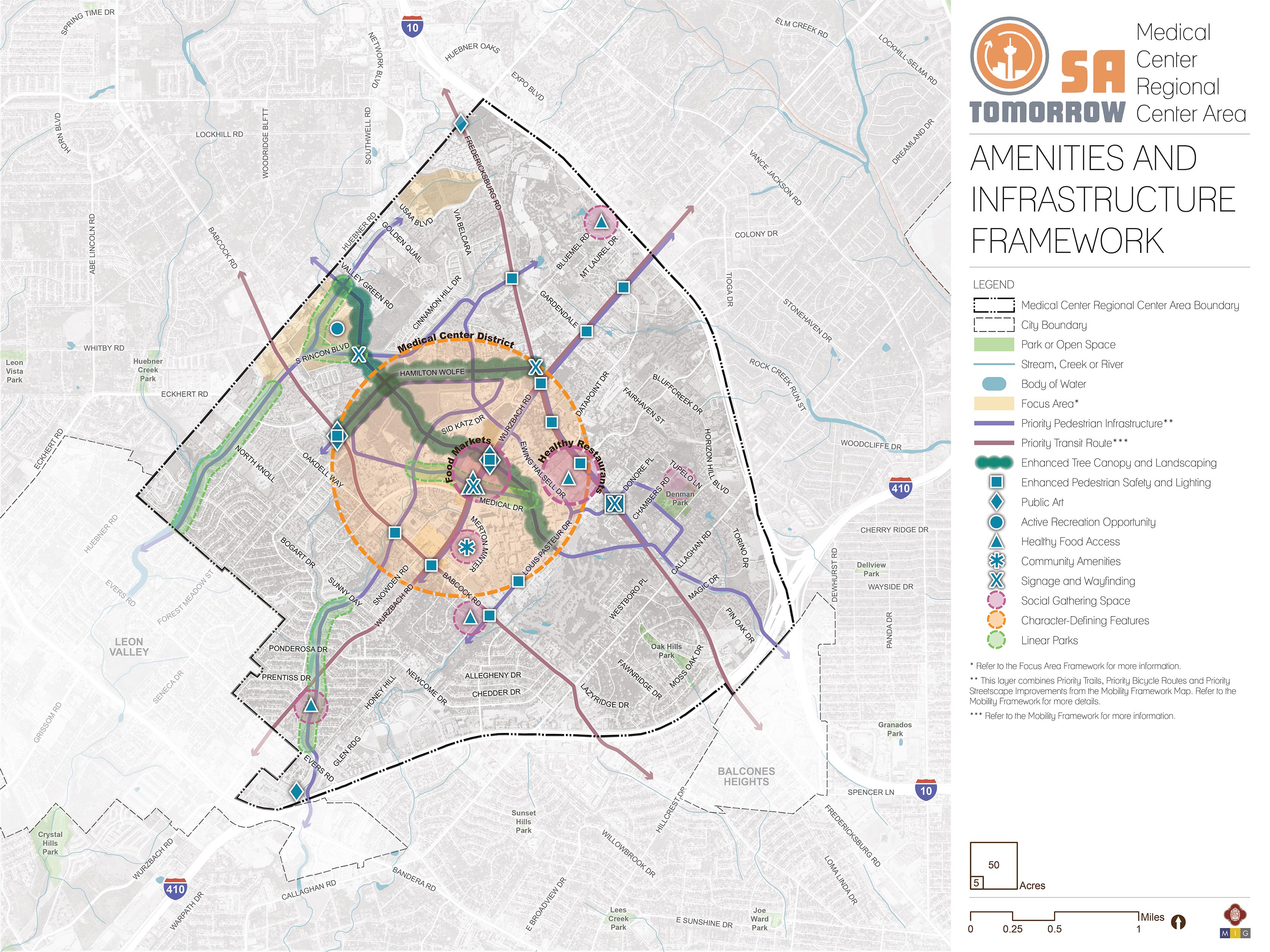
The map below highlights the Amenities & Infrastructure Framework recommendations identified for the Medical Center Area Regional Center. Scroll down learn more about the vision for Amenities & Infrastructure in the Plan Area.
To provide specific feedback on the map, please click and drag a box on that location of the map and fill out the comment box. We would love to hear more from you!
You can also visit the bottom of this page to leave additional feedback.
Recommendation #1:
Create linear parks that leverage the natural features and drainage ways of the Medical Center Area.Proximity and access to nearby green spaces and places of recreation is a major missing component in the Medical Center Area; open space currently only accounts for 4% of the land. The area is bounded by highways to the northeast and east, and existing residential and commercial development has not provided opportunities for or incorporated development of green space. There two small parks within the Regional Center, Denman Park and Oak Hills Park, as well as privately-operated running trails at the University of Texas Health Science Center and USAA. Increasing the number of, and access to, green spaces and trails will enhance the quality of life for residents, employees, and visitors of the Regional Center.
Underutilized creek spaces, such as the Huebner Creek tributary, can be redeveloped and linked with the surrounding greenway trail systems. The Huebner Creek tributary is prone to flooding, especially northwest of the Regional Center, including the Huebner-Onion Natural Area Park. The City of Leon Valley Master Plan discourages development along and over the creek area within their city boundaries and the City of San Antonio has designated the area as requiring stormwater detention.
Careful redevelopment of these creeks for recreational use will reduce the potential for increased flooding to due irresponsible development. An increase in natural greenways also contributes to an increase in opportunities for outdoor physical activity and multimodal connectivity throughout the Center.
Recommendation #3:
Increase the presence of the tree canopy coverage and improve landscaping along streetscapes and public community areas.The connection between beautification, functionality, and walkability of a street is the common presence of landscaping and significant tree canopy. The Medical Center Area Regional Center has many major thoroughfares classified as Primary Arterial Type A or Secondary Arterial Type A, according to the City’s Major Thoroughfare Plan. These arterials are the largest types of non-freeway roads, with the highest capacity and highest utilization rate. Although automobiles are well accommodated through the Regional Center, it is important to note that there are many that still travel throughout the area by foot, whether for recreation or need. In order to provide a friendlier environment for pedestrians and thus reduce the need for vehicular usage for short trips within the Center itself, it is vital to have landscaping and tree canopy coverage over these major arterials.
The South Texas Medical Center Master Plan found that there was a major need to transform the Floyd Curl Drive corridor, which runs directly through heart of the Center in a northwest to southeast direction. Floyd Curl Drive also connects Methodist Hospital, University of Texas Health Science Center of San Antonio, University Hospital, St. Luke’s Baptist Hospital, South Texas Research Facility, University of Texas Health San Antonio School of Dentistry, and Methodist Plaza. The proposal known as the Floyd Curl Green Street was proposed to begin at Louis Pasteur Drive to the south and end Hamilton Wolfe Road to the north. The project commenced in the early part of 2018 and was complete by the close of the year. The proposal for Floyd Curl Green Street includes a two-way cycle track, a buffer between bicyclists and cars, and landscaping that creates a multimodal environment that can safely be used by bicyclists, pedestrians, and motorists.
Hamilton Wolfe is also identified as an area that would be improved by a street tree canopy. Hamilton Wolfe begins at Babcock Road, intersects Floyd Curl, and ends at the intersection at Fredericksburg Road. A street tree canopy will be more inviting to pedestrians and cyclists using Hamilton Wolfe as an east-west connection in the north central portion of the plan area. Amenities and Infrastructure
Recommendation #4:
Increase pedestrian safety and lighting along main corridors.The current infrastructure within the Regional Center was developed with the safety of motorists as the primary focus for the roadways and major corridors. The secondary focus was usage for pedestrians. There is a shortage of corridors that allow one or two pedestrians to safely use sidewalks as a means of transportation or recreation at the same time. Many of these sidewalks are too narrow, have utilities located in the center blocking usage, or do not meet ADA requirements. In aligning with Amenities and Infrastructure Recommendation #3, it is crucial to increase opportunities for pedestrian usage.
The Medical Center Area currently has a residential population of 39,000 residents and that population figure is expected to increase by an additional 35,000 residents by the year 2040. Accommodating this type of growth not only demands more housing stock and more multi-modal transit options, it also requires that existing infrastructure be enhanced.
Pedestrian safety can be achieved by increasing the width of sidewalks to make them usable for all persons, ensuring sidewalk paths are continuous and not broken, or providing a larger buffer between the roadway and a sidewalk by adding a bicycle lane or landscaped path. The City’s SA Tomorrow Multimodal Transportation Plan recommends pedestrian refuge islands every half mile on Babcock Road and extending sidewalks north of Huebner Road. Within the Fredericksburg Road Corridor, the plan also recommends midblock pedestrian crossings with refuge islands. In addition to these improvements, it is vital to include other pedestrian enhancements, including, but not limited to lighting, well designed crosswalks, and ADA compliant curb ramps. Finally, areas that are not well lit tend to be more prone to crime and put pedestrians at risk during the evening.
The need for enhanced pedestrian safety in the Medical Center Area is also driven by its role as a major hub for VIA Metropolitan Transit’s bus routes. More than ten bus routes intersect in the area, including major routes 520, 534, 100, and 101, bringing in riders from all surrounding areas of the City.
Recommendation #5:
Create a district identity by incorporating character-defining features into the Center.Each regional center within the City is unique. The Medical Center Area Regional Center Plan recommends creating a framework that guides and creates cohesive development. A major component of that cohesion is creating character-defining features that help define and differentiate the function, aesthetic, and lifestyle of the area.
A neighborhood or district is often distinguishable by its historic design or unique features or characters. The Medical Center Area Regional Center, as indicated in its name, is the hub of most major medical employment and educational institutions within the City. The Regional Center is unique because it is defined by its uses, rather than by the existing character of the area. In contrast to other parts of San Antonio defined by more consistent residential areas, the Medical Center Area is made up of disconnected residential neighborhoods, commercial strip centers, minimal green space, and inward-looking employment facilities.
To help define the Medical Center Area as a distinct, recognizable, and desirable part of the City, it is essential that character-defining features are incorporated into the Center. These features, including wayfinding signage, public art, or the public spaces of Recommendation #2 should be focused in the core area of the Regional Center, bounded by Hamilton Wolfe Road to the north, Fredericksburg Road to the east, Louis Pasteur Drive to the south, and Babcock Road to the west.
Amenities and Infrastructure Components
Parks, Trails and Open Space
The Medical Center Area Regional Center has a limited amount of publicly accessible green space. The green space inventory includes two public parks, Denman Park and Oak Hills Park, and privately-operated running trails at the University of Texas Health Science Center and USAA. The City’s Parks and Recreation Department has proposed extending their current greenway trails program into the Regional Center by activating parts of the Huebner Creek tributary, which will encourage more recreation and increase connectivity.
Enhanced Streetscape
The Regional Center includes many major corridors that must accommodate motor vehicles, pedestrian, bicycle, and public transit usage. In order to make pedestrian and bicyclist activity safer, it is crucial to enhance the streetscape by widening sidewalks, adding more defined crosswalks, increasing/adding street lighting, and incorporating more landscaping and street trees. The community wants to be able to safely access nearby uses, including greenways and restaurants, and these features are crucial to creating this type of environment.
Community Amenities
Regarding community amenities, the community expressed a strong interest in new healthy food options, outdoor gathering spaces, and incorporating district defining character design. The layout and uses of the community are disconnected because each use was individually created. These amenities and design features will create a cohesive feel to the community and serve existing residents as well as encourage visitors to enjoy the Center.